Michael and I discovered Spartan Races a year and a half ago when I was invited to participate on a women's team for a Spartan Sprint in Burnet, Texas. I had no idea what a Spartan Race was, but when I learned that it involved mud and crazy physical obstacles like climbing a rope, balancing on logs, jumping or climbing over 8' walls, crawling under barbed wire and other fun stuff, I was ready to sign on the dotted line. Unfortunately, the rest of the women's team decided they didn't have enough time to train, so they all chose not to register. Our unofficial "team" ended up being me, my husband, Michael and my brother-in-law, Juan. After the first race, we were hooked. We have been training for one Spartan Race or another for the better part of a year and a half. This year, after completing the Burnet Sprint for the second time (with much more competitive results!), Michael and I signed up for the Glen Rose Spartan Beast. A Sprint is between 4 and 8 miles, and a Beast is from 12 to 16 miles. The mid-distance race is a Spartan Super, which is from 8 to 12 miles. We learned that if you complete all three of these events in one calendar year, you earn a Trifecta Medal. Since we were going to have 2 out of 3, we started looking for a Super we could run. Lo and behold, the Mid-Atlantic Super in Nellysford, Virginia was along a route we were interested in taking with the kids. Being slightly insane, we signed up for that one, as well.
We figured out right away it takes a little more logistical planning to run a race out of state. In addition to transportation and accommodation planning, we also had to think about having everything we might need while on a road trip, and how to transport and clean our muddy gear after the race. It also was pretty difficult for me to train, as the race was several weeks into a planned road trip with the kids. Somehow, we managed to figure all of the details, and race day arrived with us feeling relatively prepared.
The race venue was Wintergreen Ski Resort near Nellysford. It's up in the Appalachian mountains near the Blue Ridge Parkway. We went in figuring that there would be some pretty good hills (mountains?) and trail running, so we'd tried to train for that. The views driving up Hwy 81 in Virginia were stunning, but seeing the mountains made us realize that however much we'd tried to run hills in San Antonio, the mountains of Virginia are a different beast altogether.


Race day dawned, and we were up not long after 5am to eat breakfast and drive the 30 minutes to the parking for the event. Then we caught a shuttle bus to take us up the mountain to Wintergreen for registration. We had decided to go ahead and use our new Nathan Intensity hydration vests (similar to a CamelBak) as a trial run for the upcoming Beast race. Since the vests have several pockets, we also loaded up with some Honey Stinger gels and waffles, Gatorade chews, a Kind bar, and various other fuel in case we needed it. We loaded our water and Gatorade mix into the vests in the parking lot before hopping on the shuttle. (Side note: I really like the fact that the Nathan brand water bladder opens all the way across the top to make it easy to fill and easy to clean!)
As our shuttle bus tried to squeeze past another oncoming bus around a turn coming into the resort, the buses clipped one another, and the window two seats in front of us shattered as the back corner of the other bus slid by. Safety glass rained down all over the unlucky occupants of that seat. In good Spartan spirit, several other racers helped them to pick it off of themselves once the bus stopped, but it didn't seem like a particularly good omen to start the day.
It was a cool morning - only 53 degrees when we arrived, but we warmed up and checked our bags and prepared to start the race.
We couldn't see much of the course to know what we were in for, but the information Spartan sent out the week before the race said that it would be some steep terrain and straight into the woods at times. They said that the best times would be around 80 minutes and the slowest would come in around 6 hours. I figured my last Sprint was over 5 miles in just under an hour and a half, so I was expecting 3 hours for this race, maybe 3.5 if the terrain was really steep. Michael's heat started 15 minutes before mine, so after seeing him off to the start and heading back up for one last bathroom break before beginning, I saw that race organizers had posted a map of the course. You could tell at a glance that the course took you up and down every single ski slope at the resort. That didn't sound great, but it was time for my heat to start and so off I went.


I could tell a few minutes into the course that it was going to be tough. They sent us up a steep hill right off the bat, with some walls to hop over for good measure. By the top of the first hill (mountain), I revised my goal of finishing with a good time to just getting through the course without embarrassing myself. Through the first couple of miles, I passed about 10 other women. By about mile 2 I had some very athletic folks from the heats after mine catching me. I was hanging in there on the uphills and jogging a bit on the downhills when they weren't too steep for the first few miles, and breezed through the obstacles on that part of the course, as well. Here's an official race photo from the sandbag carry.

It became apparent early on that there was not going to be any flat ground to run on. Every time you finished climbing to the top of a steep slope, the course turned sharply and you started back down a steep, muddy and slick slope, or off through the woods where no trails have ever existed, but always on a steep incline going up or down. This made it impossible to run on the uphills, and created a huge strain on my knees on the downhills. By about mile 4, my knees were screaming with every downhill step. When we hit the mile 5 marker, we had just passed a couple of obstacles and started up a steep, long slope. It was drudgery at that point, with people just trudging slowly along, frequently stopping to sit for a minute or to flop in the grass to catch a breath. I tried to keep moving as much as possible, just one little step after the next. When it looked like I was about to crest the hill, the course turned to the right and I could then see that the path continued up an even steeper hill, and I wasn't even halfway to the top. It was a demoralizing moment, but I took some satisfaction from the fact that most of the people around me looked even more miserable than I felt. I heard some runners comment at this point that it looked like a herd of zombies staggering and moaning up the hill. I would love to post photos of this part of the race, but I noticed that none of the race photographers seemed to want to climb up the mountain to get the shot. Strange, huh?
The climb from hell turned out to be over 1 mile, pretty much straight up. At least we had a water station on top of the mountain at mile 6, but that wasn't much consolation since I then had to start down the steep slope where my knees started screaming again with every step. We climbed from the bottom of the mountain all the way up to where these apartments are pictured. This was the view of them from the finish area. The view off the top of that slope was beautiful. I wish I'd been able to carry a camera to capture it, but not enough to take one and climb that mountain again.

After coming down the horrible slope, I was feeling pretty depleted. Then we hit the log carry obstacle. You had to grab a log from the stack, then head down a ski slope. And then down some more. And even more. You could probably call it torture at that point, since every step had me wincing on the downhill, with the added benefit of knowing eventually you were going to hit the bottom and then loop around and have to carry the heavy log every bit of the way back up to the top. In a Spartan Race, if you fail an obstacle you must do a 30 burpee penalty before you can continue. By the time I started back up the hill I was wishing I had just taken the penalty at the top and skipped the whole thing. I had to pause a few times along the way, but I made it back up in one piece, as did Michael.


At around this point, another racer with a GPS device mentioned that our elevation climb on the course had exceeded 3500', with more mountains to climb. I was really grateful that I had carried the hydration vest and fuel, and started having to share some of my snacks with other racers who were trembling and suffering from leg cramps. It seemed as if the end of the course would never come. At one point we started into a rocky creek bed and climbed down the mountainside over wet, muddy and unstable rocks. The thought crossed my mind that if anyone slipped and broke an ankle, the rescue workers would have to climb out the same way we were, and that would be a slow and hazardous proposition. It's the first time during an obstacle course race where I really felt like they had taken it too far, and I wasn't very happy about the fact that it would be so difficult for help to come if you took a misstep. I was particularly upset about the fact that the course had been underestimated so badly in the information that came out prior. I think racers need to know what to expect so they can prepare and make an informed decision about what they are able to endure. Thankfully, I made it through that section safely, as did the racers around me. We finally reached the home stretch, which in this case -- Surprise! -- stretched up another long mountain, this time with an inverted wall climb, a rope climb out of muddy water, a climbing wall traverse and an inclined wall with a rope to conquer before the fire jump, the gladiators and the finish line. I've never been so happy to make it a finish line!


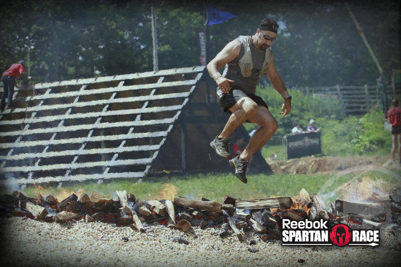
I love Michael's fire jump photo - he looks like he is falling out of the sky.
When it was all said and done, the fastest finishers ran the race in just under 2 hours, and the slowest were closer to 11.5 hours. The course was nearly 9 miles long. Over the two days of the race, over a thousand racers took longer than 6 hours. That made me feel quite a lot better about my finish in just over 5 hours. Michael came in at around 4:40. We both felt a tremendous sense of accomplishment at surviving this course and finishing the race.
After catching our breath, we headed down to shower off in icy water and clean up for the ride back to the hotel. We skipped the power wash in lieu of the garden hose variety, but it was entertaining to watch other racers opt for the quick method.
We're signed up for the Beast in December and another Super next year, but somehow I think that the terrain in Texas will seem quite enjoyable compared to the Virginia mountains. If we could finish this race, we can finish anything. (Note to race organizers - that was not a dare!)
In spite of this race being far more difficult than we - or anyone else - had anticipated, I'm glad we did it. There's nothing quite like challenging yourself physically beyond what you think you can accomplish, and then rising to the occasion. It's a feeling that truly motivates you when times are tough. I wish that everyone would endeavor to experience that feeling. Your next chance to race with us is December - still plenty of time to train!